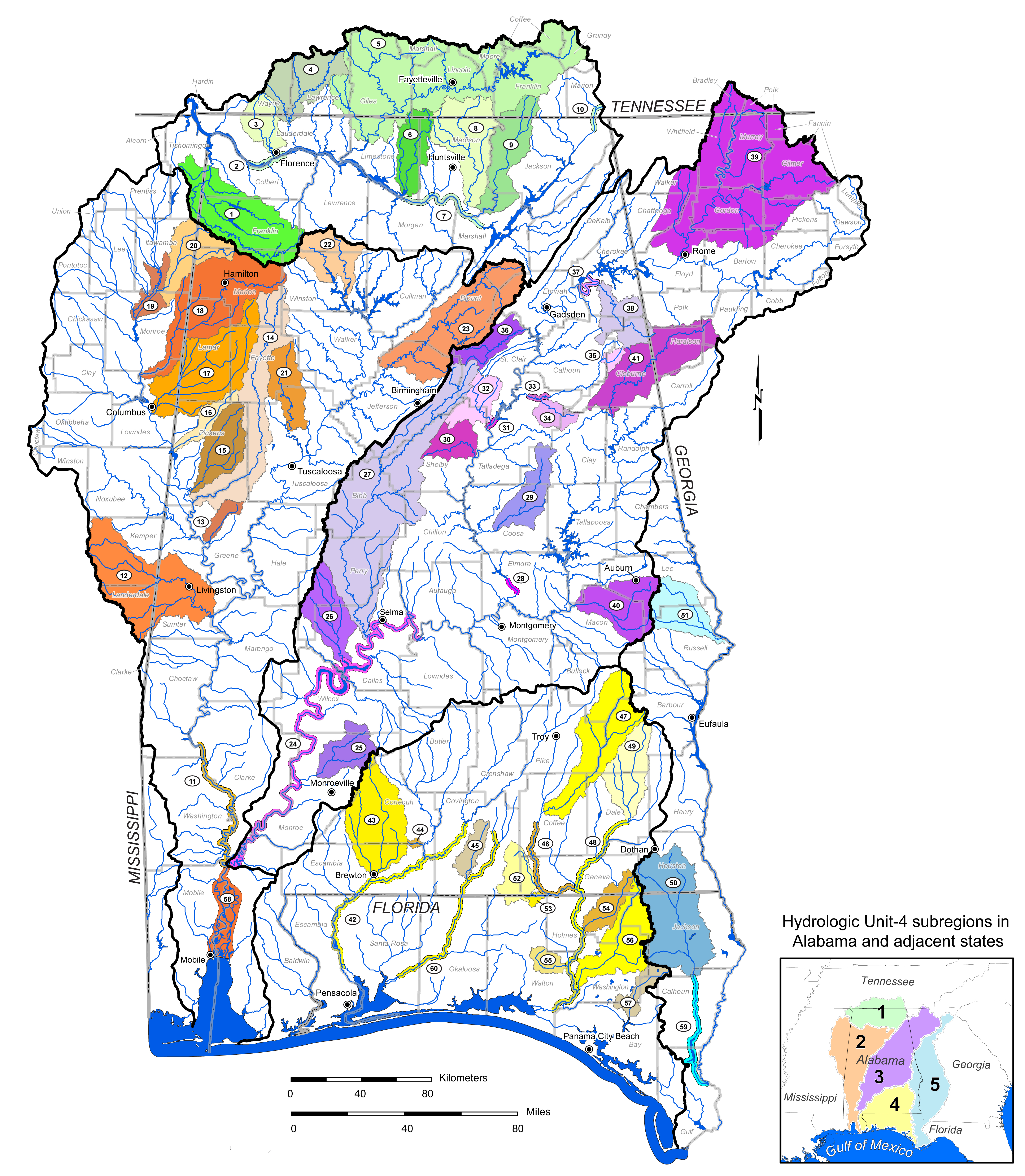
The United States Fish & Wildlife Service, Alabama Department of Conservation & Natural Resources and Geological Survey of Alabama have selected priority watersheds (SHUs) and river corridors (SRRUs) to focus activities for the management, recovery, and restoration of populations of rare fishes, mussels, snails, and crayfishes.   The Strategic Habitat Units (SHUs) and Strategic River Reach Units (SRRUs) contain a substantial part of the area's remaining high quality water courses, and reflect the variety of aquatic habitats occupied by these species - both historically and presently.

These units were selected based on:
  • the presence of federally listed and state imperiled species
  • the designation of critical habitat for these species
  • expert knowledge about essential habitat components required for these species to survive
  Suitable habitat for these species includes:
  • areas with geomorphically stable stream and river channels
  • suitable flow regimes
  • clear water
  • a diversity of channel substrate types with minimal amounts of fine sediment and filamentous algae
  • few or no competitive or predaceous nonnative species

The purpose of designating SHUs and SRRUs is to facilitate
watershed management and restoration efforts addressing
habitat and water quality issues.
  Click here for a higher resolution map of the Strategic Habitat Units (Special Map 248-B)


Strategic Habitat Units by sub-region
1.)  Middle Tennessee - Elk
       sub-region
2.)  Mobile - Tombigbee
       sub-region
3.)  Alabama sub-region 4.)  Choctawhatchee -
     Escambia sub-region
5.)  Apalachicola
       sub-region
1.  Bear Creek 12.  Sucarnoochee River 25.  Big Flat Creek 43.  Murder Creek 50. Upper Chipola
River
3.  Cypress Creek 13.  Trussels Creek 26.  Bogue Chitto Creek 44.  Amos Mill Creek 51. Uchee Creek
4.  Shoal Creek 14.  Sipsey River 27.  Upper Cahaba River 45.  Five Runs Creek  
5.  Elk River 15.  Lubbub Creek 29.  Hatchet Creek 47.  Upper Pea River  
6.  Limestone Creek 16.  Coalfire Creek 30.  Yellowleaf Creek 49.  West Fork Choctawhatchee River  
8.  Flint River 17.  Luxapalila Creek 32.  Kelly Creek 52.  Flat Creek  
9.  Paint Rock River 18.  Buttahatchee River 34.  Cheaha Creek 53. Limestone Creek  
  19.  East Fork
Tombigbee River
35.  Shoal Creek 54.  Wrights Creek  
  20.  Bull Mountain Creek 36.  Big Canoe Creek 55. Bruce Creek  
  21.  North River 38.  Terrapin Creek 56.  Holmes Creek  
  22.  Upper Sipsey Fork 39.  Oostanaula River 57.  Econfina Creek  
  23.  Locust Fork 40.  Uphapee Creek    
  58.  Mobile-Tensaw River delta 41. Upper Tallapoosa River    
 
Strategic River Reach Units by sub-region
1.)  Middle Tennesse - Elk           sub-region 2.)  Mobile - Tombigbee
      sub-region
3.)  Alabama sub-region 4.)  Choctawhatchee - 
      Escambia sub-region
5.)  Apalachicola  
       sub-region
2.  Tennessee River
downstream of Wilson Dam
11.  Lower Tombigbee River 24. Lower Alabama River 42.  Conecuh-Escambia
River
59.  Lower Chipola River
7.  Tennessee River
downstream of Guntersville Dam
  28.  Coosa River downstream of Jordan Dam 46.  Lower Pea River  
10. Tennessee River downstream of Nickajack Dam   31. Coosa River downstream of Logan Martin Dam 48. Lower Choctawhatchee River  
    33. Lower Choccolocco
Creek
60.  Yellow River  
    37.  Weiss Lake bypass
(historic Coosa River channel)